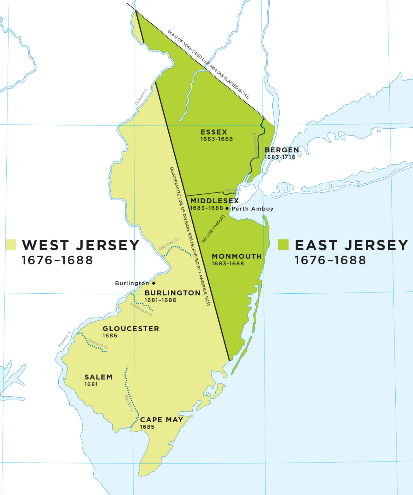
Map of East and West Jersey
Lesson Creator: New Jersey Center for Civic Education, Rutgers University, Piscataway, NJ
Grade level: Elementary Grades
Objectives: Students will demonstrate an understanding of how New Jersey became an English colony.
New Jersey Student Learning Standards for Social Studies (2020):
- 6.1.5.GeoSV.5: Use geographic data to examine how the search for natural resources resulted in conflict and cooperation among European colonists and Native American resulting in changes to conditions.
- 6.1.5.GeoGI.1: Use multiple sources to evaluate the impact of the movement of people from place to place on individuals, communities, and regions.
- 6.1.5.GeoGI.2: Use historical maps to explain what led to the exploration of new water and land routes.
- 6.1.5.GeoGI.3: Use geographic tools to determine factors that impacted emigration, settlement patterns, and regional identities of the US colonies.
Focus Questions:
- How did the decisions of individuals and groups influence the creation of New Jersey and the United States?
- What is a colony?
- Why were colonies beneficial to the mother country?
- How did the area of New Jersey become a British colony?
Glossary:
- Colony: a group of people who move from where they were born to another land but are subject to the control of parent country.
- “Mother country”: a country where colonists came from to live in another land. For example, although individuals from many nations have immigrated to the United States, England was the mother country of the United States when it was a series of colonies under its control in the 1700s.
- Proprietors
Opener: New Jersey did not start as an English colony! Swedes, Finns, Dutch and English all settled on the land that became New Jersey, buying or taking land from the Native Americans that were living on the land.
Day One: What is a colony? Why were colonies beneficial to the mother country?
Have a class discussion about what a colony is and why colonies were beneficial to the mother country.
A colony is a group of people who immigrated (moved) from where they were born to another land but are subject to the control of the parent or mother country. For example, England was although individuals from many nations have immigrated to the United States, England was the mother country of the United States when it was a series of colonies under its control in the 1700s. Colonies were beneficial to the mother country because they provided a course of raw materials and for exports, increasing the economic power of the mother country.
Day One: New Netherlands
Background: Around 1524, Giovanni de Verrazano, a Florentine explorer sailing for King Francis I of France, was the first European to explore New Jersey. In 1523-24, he voyaged along the coast from Newfoundland to Cape Fear, North Carolina, anchoring off Sandy Hook in New York Bay where he encountered Lenape Native Americans. During the 1600s, Europe was undergoing expansive social, cultural, and economic growth. Nations vied for domination of lucrative trade routes around the globe, particularly those to Asia. In the Americas, the English had a settlement at Jamestown, Virginia, the French had small settlements at Port Royal and Quebec, and the Spanish were developing colonies in South America and the Caribbean.
The colonial history of New Jersey began in 1609 when Henry Hudson first claimed the region on behalf of Holland and renamed it New Netherlands. Hudson was an English sea captain and explorer who sailed three times for the English in 1607 and 1608 looking for, but failing to find, a Northeast Passage from Europe to Asia through the Arctic Ocean. Finding nobody in England to support another voyage, in 1609 he sailed for the Dutch East India Company. He explored the waters off the northeast coast of North America at Newfoundland and Cape Cod. Hudson believed that the passage to the Pacific Ocean was between the St. Lawrence River and the Chesapeake Bay, so he sailed south to the Bay, then turned northward, traveling close along the shore. From Delaware Bay, he began to sail upriver looking for the passage. After passing Sandy Hook, Hudson and his crew entered the Narrows into the Upper New York Bay. Hudson thought that he had found the continental water route, so he sailed up the major river that now bears his name. He found the water too shallow to proceed several days later at the site of Troy, New York.
Upon returning to the Netherlands, Hudson reported that he had found a fertile land and an amicable people willing to engage his crew in small-scale bartering of furs, trinkets, clothes, and small manufactured goods. It was the catalyst for Dutch merchant-traders to fund more expeditions. The Dutch West India Trade Company subsequently gave out land grants to encourage settlement, attracting many migrants from Sweden as well as Holland. Cornelius Jacobsen Mey and other Dutch sailors explored, surveyed, and mapped the area between Maryland and Massachusetts in four voyages made between 1611 and 1614. These surveys and charts were consolidated under the name New Netherland (it was also called Nova Belgica) for the first time on maps.
Map Activity: Share Handout 1: Map of New Netherlands with your students and ask them to identify the land that became New Jersey on the map.
Day One: New Sweden
Background: Hoping to advance its world power status and become a dominant member of the European economic market, in 1637 the Swedish government permitted the formation of a New Sweden Trading Company to sponsor a voyage to the new world to trade with the native population. Landing on the banks of the Delaware River in 1638, Swedish settlers set up a trading colony which ultimately extended from just north of Trenton, New Jersey to as far south as Wilmington, Delaware—including the land that the Dutch Fort Nassau sat on. The Dutch protested Swedish claims to the land on the Delaware as early as 1639, but since they, like the Swedes, had few soldiers, neither side was able make a decisive move against the other. Around late 1641-early 1642, however, the two groups temporarily stopped bickering and combined their efforts to evict a group of sixty English men and women, who had come to establish England’s claim to the region.
The first English settlers on the Delaware River were representatives of the English Delaware Company based in New Haven, Connecticut. Finding the area around the Delaware to be sparsely populated, the Company was successful in purchasing tracts of land from the region’s Natives. Having purchased its land, the Company sent a group of sixty settlers to establish two new communities; one at present-day Salem, New Jersey. Both the Swedes and the Dutch felt threatened by the English presence and their almost instantaneous monopolization of the region’s Indian fur trade. Tired of having to compete for furs and living in fear of their developing a more substantial settlement, the Swedes and Dutch joined forces and forcibly removed the English from the region. For information on New Sweden go to https://libraries.psu.edu/about/collections/unearthing-past-student-research-pennsylvania-history/new-sweden-brief-history.
Day One, Map activity: Have students locate some of the early Swedish settlements on the map of New Jersey (Handout 2).
Day Two: The English Provinces of East and West Jersey
After a war with the Dutch, which England won in 1664, the Dutch ceded its New Netherlands colony to the English. English King Charles gave the region between New England and Maryland to his brother, the Duke of York (who later became King James II).
Soon thereafter, the Duke of York granted the land between the Hudson and Delaware Rivers to Sir George Carteret and Lord Berkeley, who had been loyal to him through the English Civil War, and named New Jersey after the English Channel Island of Jersey. As a result, Carteret and Berkeley became the two English Lords Proprietors of New Jersey. The two proprietors of New Jersey attempted to attract more settlers to move to the province by granting sections of lands to settlers and by passing the Concession and Agreement, a 1665 document that granted religious freedom to all colonists of New Jersey. There was no religious freedom in English where the Anglican Church was the established religion for everybody.
In 1673, Lord Berkeley sold his share of New Jersey to two Quakers and New Jersey became divided into two proprietary (that is, administered by the owners or “proprietors”, rather than the king) colonies: East Jersey and West Jersey, with very different governments. Several different surveys lines were drawn differentiating East and West Jersey (surveys were not perfectly accurate in those days—several surveys on Handout 3). With low prices for land and religious and political freedom, East and West Jersey were able to attract new settlers and grew quickly.
The political division of East and West Jersey existed until 1702 when governing rights were given up to British Queen Anne and East and West Jersey were united as the Province of New Jersey. For many years, New Jersey shared a royal governor with New York. The governorship was finally split in 1738 when New Jersey got its own governor, Lewis Morris.
Day Two, Map activity: Have students find the approximate location of their town on the map (Handout 4) and determine if it was initially part of East or West Jersey.
Critical Thinking activity: Have students consider the early history of New Jersey and explain how it was commercial interests and rivalry among European monarch that led to the exploration and settlement of New Jersey.
Handout 1:
New Netherland (“Nova Belgica/Nieuw Nederland”)
Can you pick out New Jersey on the map?

Handout 2: Identify New Sweden (North of Trenton, NJ to Wilmington, DE along the Delaware River)

Handout 3: Survey lines for East and West Jersey

Handout 4: East and West Jersey