
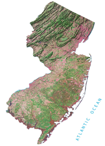
Grade level: Elementary
Objectives: Students will demonstrate their understanding of New Jersey’s geography and its impact on where people live and what they do.
New Jersey Student Learning Standards for Social Studies (2020):
6.1.2.GeoPP.1: Explain the different physical and human characteristics that might make a location a good place to live (e.g., landforms, climate and weather, resource availability).
6.1.2.Geo.SV.1: Use maps to identify physical features (e.g., continents, oceans, rivers, lakes, mountains).
6.1.2.Geo.SV.2: Describe how maps are created for a specific purpose (e.g., school fire-drill map, route from home to school, learning centers in a classroom).
6.1.2.Geo.SV.3: Identify and describe the properties of a variety of maps and globes (e.g., title, legend, cardinal directions, scale, symbols,) and purposes (wayfinding, thematic).
6.1.2.Geo.HE.1: Explain how seasonal weather changes, climate, and other environmental characteristics affect people's lives in a place or region.
6.1.2.Geo.HE.2: Describe how human activities affect the culture and environmental characteristics of places or regions (e.g., transportation, housing, dietary needs).
6.1.2.Geo.HE.3: Identify cultural and environmental characteristics of different regions in New Jersey and the United States.
6.1.2.Geo.HE.4: Investigate the relationship between the physical environment of a place and the economic activities found there
6.1.5.GeoPP.1: Compare and contrast characteristics of regions in the United States based on culture, economics, and physica characteristics to understand the concept of regionalism.
6.1.5.GeoPP.2: Describe how landforms, climate and weather, and availability of resources have impacted where and how people live and work in different regions of New Jersey and the United States.
6.1.5.GeoSV.1: Identify the maps or types of maps most appropriate for specific purposes
6.1.5.GeoSV.2: Use maps to explain the impact of location and place on the relationships between places in New Jersey, the United States and other countries.
6.1.5.GeoSV.4: Use a variety of geographic representations to describe the similarities and differences between places in New Jersey, the United States and the world
Common Core ELA Standards:
RI.4.1 Refer to details and examples in a text when explaining what the text says explicitly and when drawing inferences from the text.
RI.4.3 Explain events, procedures, ideas, or concepts in a historical, scientific, or technical text, including what happened and why, based on specific information in the text.
RI.4.4 Determine the meaning of general academic and domain-specific words or phrases in a text relevant to a grade 4 topic or subject area.
RI.4.7 Interpret information presented visually, orally, or quantitatively (e.g., in charts, graphs, diagrams, time lines, animations, or interactive elements on Web pages) and explain how the information contributes to an understanding of the text in which it appears.
RI.4.9 Integrate information from two texts on the same topic in order to write or speak about the subject knowledgeably.
W.4.7 Conduct short research projects that build knowledge through investigation of different aspects of a topic.
W.4.8 Recall relevant information from experiences or gather relevant information from print and digital sources; take notes and categorize information, and provide a list of sources.
SL.4.2 Determine the main ideas and supporting details of a text read aloud or information presented in diverse media and formats, including visually, quantitatively, and orally.
SL.4.3 Ask and answer questions about information from a speaker, offering appropriate elaboration and detail
Essential Questions:
- What are the natural regions of New Jersey?
- How has the geography and natural resources of the different regions of New Jersey influenced their development?
- Why are some areas of New Jersey more suited for people to live in than others?
Procedures/Activities
1. Where is New Jersey located?
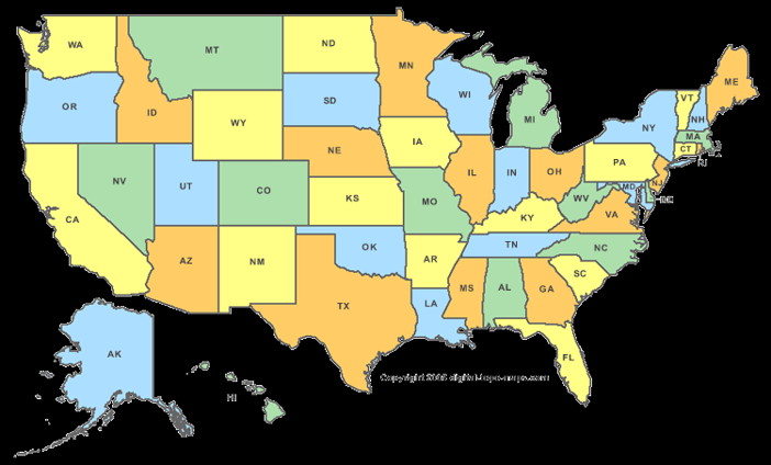
- Show students a map of the United States (Or use Handout 1).
- Point to New Jersey on the Atlantic Ocean.
- What might be the benefits and disadvantages of being next to an ocean?
2. What are the natural regions of New Jersey?
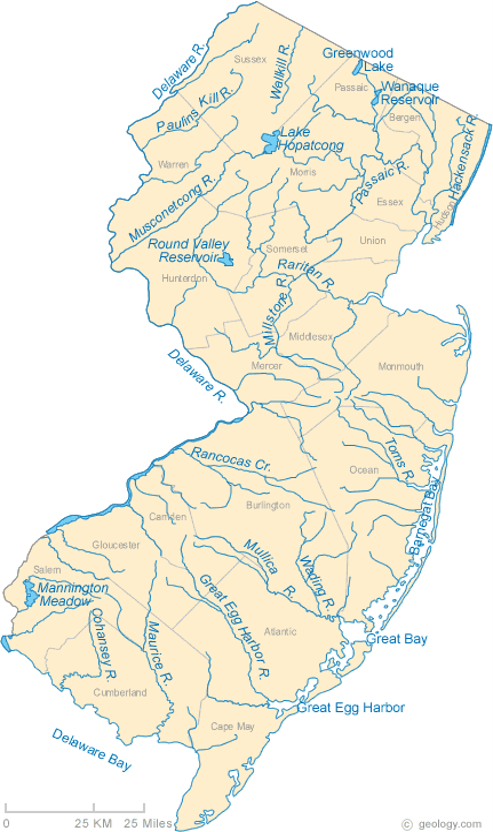
- Show students a physical map of New Jersey at New Jersey Physical Map (Handout 2) and a map of New Jersey’s rivers at Map of New Jersey Lakes, Streams and Rivers (Handout 3)
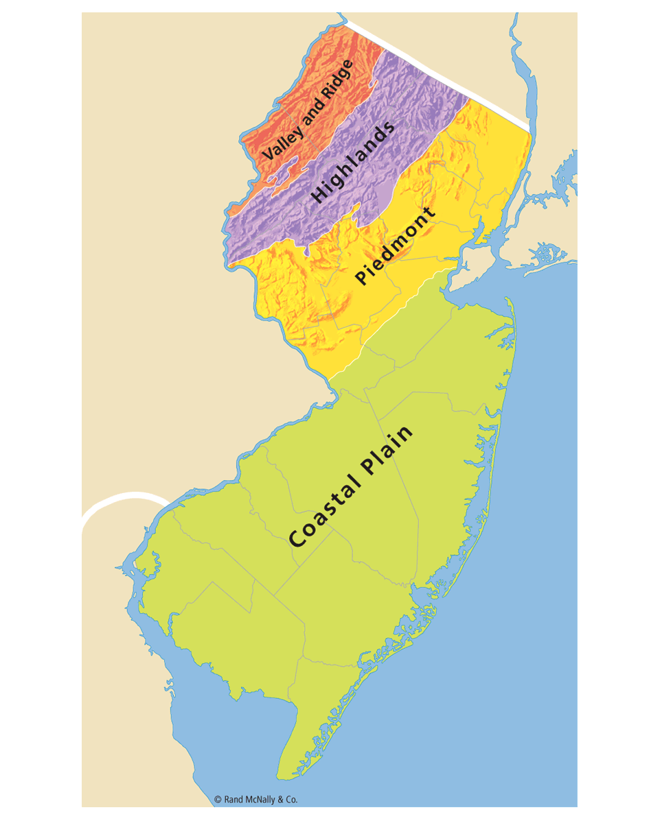
- Introduce the four natural regions of New Jersey using Handout 4. What are the physical characteristics in each region? How does geography influence what you do?
- Students may individually or in small groups read and take notes about each region from other sources: .
- Appalachian Ridge and Valley in the northwestern part of the state.
- A ridge is a long, narrow chain of mountains.
- The Kittatinny Mountains are a long ridge that crosses much of the western part of this region.
- The Highlands
- This region includes flat-topped ridges and narrow valleys to the east of the Kittatinny Mountains.
- Lake Hopatcong, the state’s largest lake, is in this region, which has many forests and lakes.
- The region is a popular place for hiking and camping.
- Piedmont Region
- Many of New Jersey’s largest cities and rivers are in this region.
- The Hudson River flows along the eastern edge of the region.
- The Delaware River is at the southern end.
- Atlantic Coastal plain
- A plain is a low, flat area.
- This region includes the central and southern part of the state.
- The western part has rich, fertile soil with farms and orchards.
The eastern part, along the coast, is sandy and covered with marshes and pine trees.
3. Where do people live in New Jersey?
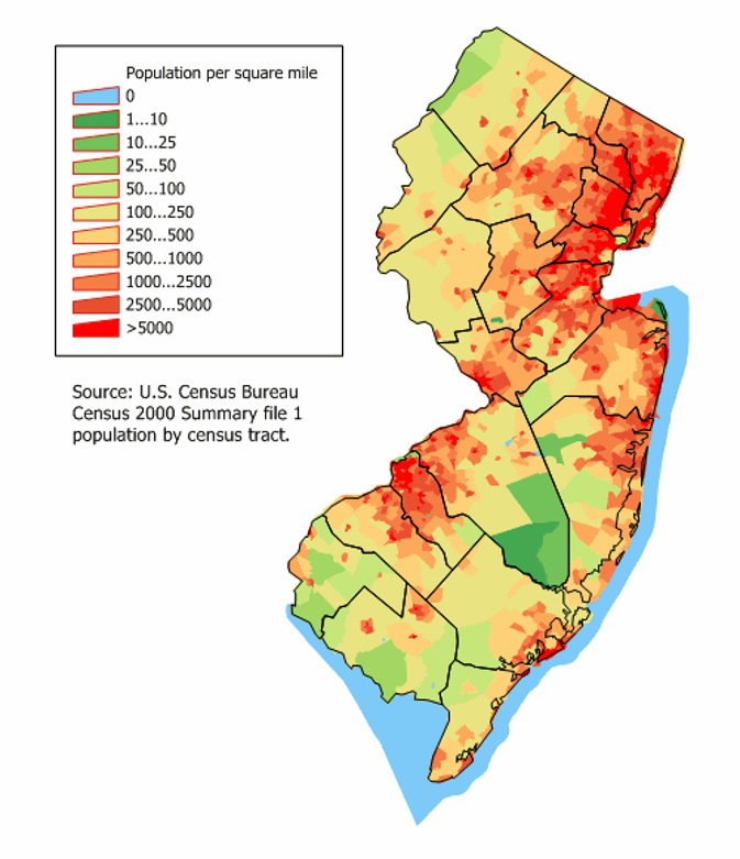
- New Jersey is the most densely populated state in the United States. Population density is determined by dividing the number of people living in an area (New Jersey’s population is 8.865 million) by the size of the state (7,417 square miles). Why do you think so many people live in New Jersey?
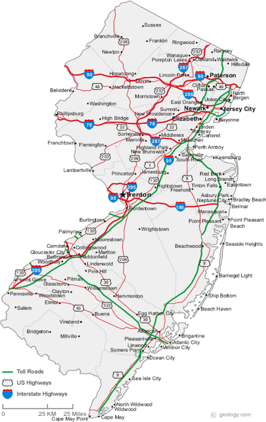
- The population is not evenly spread out across the state. See a map of NJ’s major cities at Map of New Jersey Cities and Roads (Handout 5). Do you see any connections between New Jersey’s physical geography—where the rivers and mountains are—and where its cities have developed?
- What do urban, suburban, and rural mean?
1) Urban—means a city. The U.S. Census Bureau defined “urban” in 2010 as an area having more than 50,000 people.
2) Suburban—indicates those population clusters that grew up around cities. The U.S. Census Bureau defined “suburban” population clusters in 2010 as areas with populations greater than 2,500 but less than 50,000.
3) Rural--means countryside. We think of farms and New Jersey has plenty of rural areas and farms. This would include all the areas with less than 2,500 people. - Using the Population Density Map (Handout 6) ask students to identify rural, urban and suburban areas of New Jersey, and to compare the Population Density Map with the map of New Jersey’s major cities.
- Identify the town where you live on the map with New Jersey’s major cities. Do you live in an urban, suburban or rural area?
- Why might some areas of New Jersey be more suited for people to live than others?
4. Project: Make a Travel brochure
- Distribute the directions for the New Jersey Regions Project (Handout 7)
- Ask each student to pick one region for their brochure.
- Students will use research links online to create their rough copy. Once finished, they will submit the rough copy for teacher approval before completing the final copy.
- Students will complete their final copies (at home) and share them with the class.
Assessment:
- Use rough copy as formative assessment to monitor progress
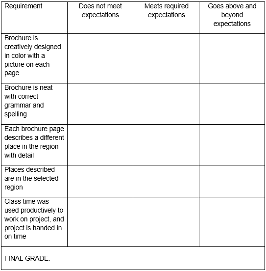
- Final project brochure graded using the following project rubric:
Handout 1: Map of the United States
Where is New Jersey?
Handout 2: New Jersey Physical Map
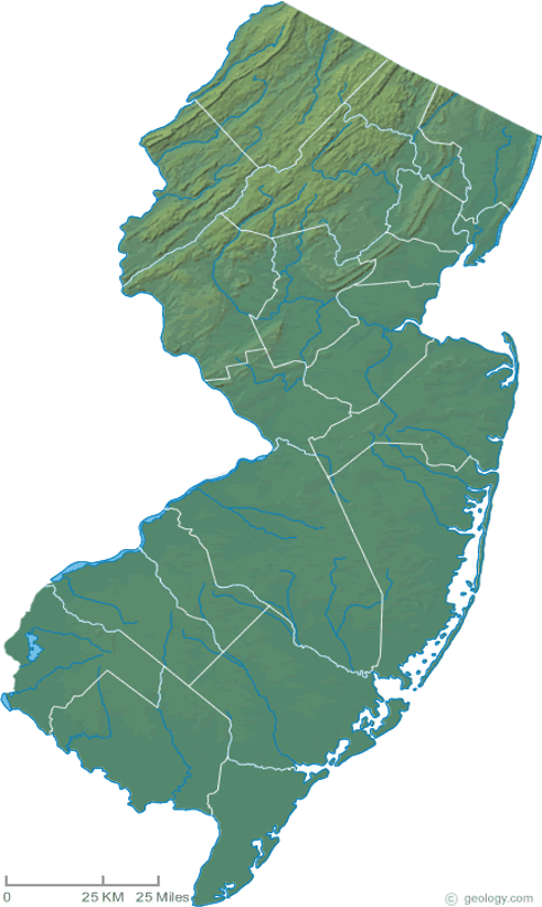
Handout 3: New Jersey Major Rivers and Lakes
Handout 4: Regions of New Jersey
Handout 5: Major New Jersey Cities and Roads
Handout 6: New Jersey Population Density
Handout 7
Region Name:
1. Study a NJ region map- where is this region located? Color it on the map to the right: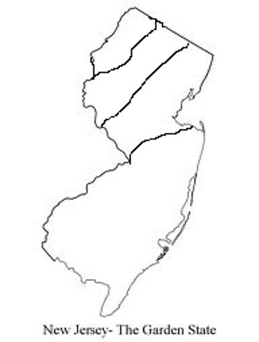
2. Describe the physical land characteristics of this region. (Hint: Are there mountains? Hills? Flat Land? Rivers? Lakes?)
3. What kind of special attractions are in this region? (Hint: Where should visitors go when they are in this region?)
4. What are other special facts about this region?
Name:
Parent Signature:
New Jersey Regions Project!
Choose one of New Jersey’s regions to use to make a travel brochure.
My Region is:
For this project, you may use the information that you collected and recorded in your Region Packet.
You should also use internet sources from my classroom website for more ideas for information and pictures to include. Please have adult supervision when using the internet at home.
FRONT COVER: You must draw and color the region that your brochure is going to be about. You must also write the name of the region on the cover.
INSIDE PAGES: There is a “Free” page for you to write extra information and draw a picture. The other inside pages have specific directions:
- The “nature” page must include a specific place for tourists to go where they can enjoy nature. Include the name of the place and write 1-2 sentences describing details about that place.
- The “special attraction” page must include a specific place for tourists to go that is fun! Include the name of the place and write 1-2 sentences describing details about that place.
- The “information” page must include 1 or 2 interesting facts about the region that the visitor might be interested in. Write 1-2 sentences describing details about the fact/facts.
BACK COVER: Write your name and include any other interesting facts of pictures.
*You should NOT color your rough copy. Your final copy needs to be neat and in color, if you want to print pictures from the computer for your project, you may do so.
For more information about a specific place in your region, see New Jersey's Unique Geology - GSWA; or see Geology of New Jersey
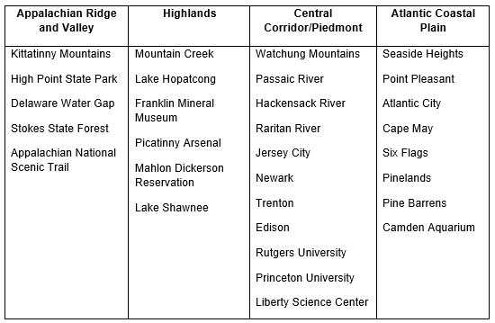
Which New Jersey Region Should YOU Visit?
Appalachian Ridge and Valley: A northern region with lots of mountains and forests.
Highlands: This region has lots of hills and the largest lake in NJ is here!
Central Corridor Piedmont: A region with lots of high, flat, plateaus. Lots of big cities are here also!
Atlantic Coastal Plain: A region with flat lowlands, fertile soil, and lots of beaches!